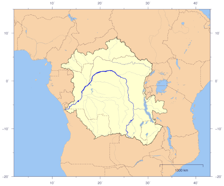
Fisye:CongoLualaba watershed plain political.png

Size of this preview: 721 × 599 pixels. Other resolutions: 289 × 240 pixels | 578 × 480 pixels | 924 × 768 pixels | 1,150 × 956 pixels.
Original file (1,150 × 956 pixels, file size: 213 KB, MIME type: image/png)
File history
Click on a date/time to view the file as it appeared at that time.
| Kilumbu/Ngûnga | Thumbnail | Dimensions | Sadi | Comment | |
|---|---|---|---|---|---|
| bubu yayi | 21:02, 3 ngônda ya ntete 2007 |  | 1,150 × 956 (213 KB) | Imagico | {{Information |Description= {{en|Course and Watershed of the Congo and Lualaba River with political boundaries.}} {{de|Verlauf und Einzugsgebiet von Kongo und Lualaba mit Staatsgrenzen.}} |Source=The map has been created with the [[:en:Generic Mapping Too |
File usage
The following page uses this file:
Global file usage
The following other wikis use this file:
- Usage on af.wikipedia.org
- Usage on ar.wikipedia.org
- Usage on as.wikipedia.org
- Usage on bcl.wikipedia.org
- Usage on bn.wikipedia.org
- Usage on ca.wikipedia.org
- Usage on el.wikipedia.org
- Usage on en.wikipedia.org
- Usage on es.wikipedia.org
- Usage on fa.wikipedia.org
- Usage on fr.wikipedia.org
- Usage on ha.wikipedia.org
- Usage on hy.wikipedia.org
- Usage on it.wikipedia.org
- Usage on ja.wikipedia.org
- Usage on jv.wikipedia.org
- Usage on kk.wikipedia.org
- Usage on ky.wikipedia.org
- Usage on la.wikipedia.org
- Usage on ml.wikipedia.org
- Usage on mr.wikipedia.org
- Usage on no.wikipedia.org
- Usage on pt.wikipedia.org
- Usage on rw.wikipedia.org
- Usage on sv.wikipedia.org
- Usage on ta.wikipedia.org
- Usage on te.wikipedia.org
- Usage on tr.wiktionary.org
- Usage on uz.wikipedia.org
- Usage on vec.wikipedia.org
- Usage on vi.wikipedia.org
- Usage on za.wikipedia.org